Where we are and why it matters
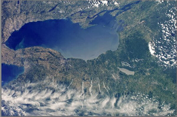 This beautiful satellite photo (also shown above) puts us in our place: Cayuga Lake is at the center of New York State’s Finger Lakes region. Click on the photo to enlarge.
Our creeks and lake waters drain north to Lake Ontario, and eventually to the Atlantic Ocean via the St Lawrence Seaway. The Cayuga Lake Watershed and our Finger Lakes neighbors are part of the Great Lakes headwaters. We have a responsibility to ourselves as residents and to everyone downstream to protect our lands and waters for generations to come.
This page is being developed to provide you with information about the Finger Lakes region and the Great Lakes Basin of which we are a part.
Come back soon for summaries and links to information about the Haudenosaunee, the Finger Lakes Regional Watershed Alliance, the Great Lakes Basin Commission, with maps, reports, videos, treaties, and much more.
Here is a great report to get you started: Managing the Water Resources of the Oswego River Basin in Central New York (US Geological Survey, revised ed. 2002). See the relation of each of the Finger Lakes to one another in terms of drainage and elevations; via maps and diagrams gain a better understanding of how to entire Finger Lakes region is hydrologically interlinked and tied into natural and human-made canal and drainage systems, all flowing to Lake Ontario.
We live at the top of a water-rich region
People who live and work in the hills south and east of Ithaca, Dryden, Caroline, Danby and Virgil often traverse a major drainage divide of the North American continent. The locally important Cayuga Lake watershed boundary is part of the longer, continentally-significant St Lawrence Divide (see map, The St Lawrence Divide in New York State).
On the north side of that line, rainfall and snowmelt drain to creeks that flow into Cayuga Lake’s southern end. Cayuga’s waters move slowly northward, into the canal at Mud Lock, eventually reaching Lake Ontario, then flowing onwards to the North Atlantic Ocean via the St Lawrence Seaway.
On the south side of that line, precipitation drains to creeks that feed the small rivers that are tributaries to the massive Susquehanna River system, which drains south to the Atlantic Ocean via Chesapeake Bay (see map, The Cayuga Lake Watershed in a Wider Context).
Our towns and neighborhoods, roads, journeys to work, school, and play straddle this upland region with its wealth of wetlands, rivulets, streams, ponds, creeks and famous waterfalls. While the Cayuga Lake Watershed Network is focused on the waters that flow to the lake down the north side of the divide, our community awareness and responsibility for headwaters protection needs to include the streams and creeks that flow southwards (see map, Where the Waters Divide, In Our Own Backyards). The concept of a “divide” forces us to artificially separate, into “one side or the other,” a regional water resource that need to be cared for in a unified manner.
We live among infant rivers
Another way to look at it is that we live among infant rivers. We are the first to encounter the young waters as they gather in our upland wetland woods, in our ditches and backyard streams, massing and spilling their clean abundance downhill, both to the north and to the south. And we bear responsibility for the downstream health of all these waters. We protect them locally for future generations and ecosystem functions of which we are not fully aware, ensuring that our downstream neighbors – all the way to the Atlantic Ocean – may also enjoy clean, abundant, healthful water.
Stewardship efforts
Several towns in Tompkins County are working on surface and groundwater studies, in cooperation with the U.S. Geological Survey and other agencies, to help inform protective planning and town-level ordinances. Creeks on both sides of the St. Lawrence Divide are regularly monitored by citizen volunteers, thanks to the Community Science Institute and the wisdom of cooperating townships. Public agencies around Cayuga Lake are supportive of clean-water initiatives.
In this era of rapid climate change and with the looming potential of large-scale rural industrial development via gas drilling and fracking, we need to be thinking in terms of protecting the entirety of this wonderful headwaters area. Since April, the NY Department of Environmental Conservation (DEC) has new regulations in place that make it easier for business interests to obtain permits for withdrawal of creek and lake water for commercial and industrial use. We need to work together to ensure that our creeks, streams, pond and lake waters are not negatively impacted by outside, water-hungry interests.
The Cayuga Lake Watershed Network’s new website is developing pages to provide maps and links to information on these topics. Especially note the Watershed, Resources, and Networking pages at www.cayugalake.org. To learn more about the legal and legislative challenges to effective water resources protection across New York State, visit environmental writer and attorney Rachel Treichler’s water law blog: http://nywaterlaw.com/index.html.
Click maps for greater detail


